

Tampilkan postingan dengan label Nature. Tampilkan semua postingan
Tampilkan postingan dengan label Nature. Tampilkan semua postingan
Fly Geyser; Amazing Geyser Landscape in Nevada
The Great Geysir in South Iceland. Erupts at Regular Intervals Every 10 Minutes or so and its White Column of Boiling Water Can Reach as High as 20-30 Metres
In southern Iceland, there is the famous Geysir, The Great Geysir or Stori-Geysir. Geysir has attracted millions of visitors who come from all over the world. They came on vacation there to witness a miracle of nature there.

Attack of the Silkworm Feather/Caterpillars (Desiciria inclusa)

Indahnya Taman Nasional Gunung Ciremai
Gunung Ciremai pastinya tidak asing dengan para pencinta alam yang sejak lama Gunung ini menjadi sarana pendakian gunung Gunung Ceremai secara administratif termasuk dalam wilayah tiga kabupaten, yakni Kabupaten Cirebon, Kabupaten Kuningan dan Kabupaten Majalengka, Provinsi Jawa Barat Posisi geografis puncaknya terletak pada 6° 53' 30" LS dan 108° 24' 00" BT, dengan ketinggian 3.078 m di atas permukaan laut.
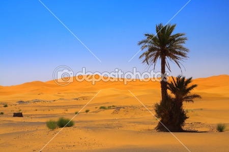
Pohon Palem Ditengah Gurun Sahara
Perlua nda ketahui, bahwa Gurun Sahara adalah nama sebuah padang pasir terbesar di dunia. Nama "Sahara" diambil dari bahasa Arab yang berarti "padang pasir".
Sahara terletak di utara Afrika dan berusia 2,5 juta tahun. Padang pasir ini membentang dari Samudra Atlantik ke Laut Merah. Dari Laut Tengah di utara sampai ke Sahel di sebelah selatan. Dari Mauritania di sebelah barat ke Mesir di sebelah timur. Padang pasir ini membagi benua Afrika menjadi Afrika Utara dan Afrika "yang sejatinya". Kedua bagian benua ini sangat berbeda, baik secara iklim maupun budaya. Luas padang pasir ini sekitar 9.000.000 km2. (wikipedia)
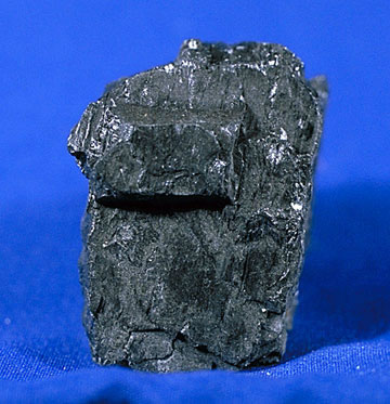
Bukit Asam Coal Mining
Coal or coal is one of fossil fuels. General understanding is a combustible sedimentary rock, formed from organic sediments, mainly remnants of plants and are formed through the process pembatubaraan. Its main elements consist of carbon, hydrogen and oxygen.
Coal is also an organic rock that has the properties of the complex physics and chemistry that can be encountered in various forms.
Element analysis provides an empirical formula such as C137H97O9NS formula for bituminous and anthracite C240H90O4NS.
Activities of Sulphur Miner at Kawah Ijen
To reach Ijen, you have to down a path along the caldera cliffs. Do not forget to bring life cover because sometimes the sulfur smoke is blown through the track. You can also surround the caldera in the region which takes eight to 10 hours to reach on foot.
There, many miners Sulfur their activities. Armed with crude equipment, they try to mine the sulfur as their livelihood. Look at how hard they Sulphur mine, please refer here on.

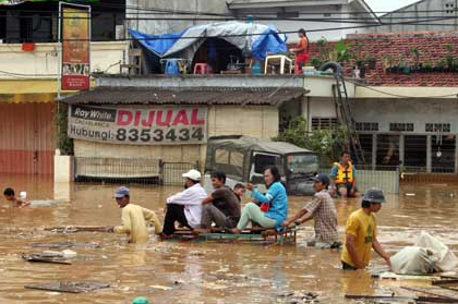
Other Side of the Flood in Jakarta
Jakarta floods in 2007 were floods that hit Jakarta and surrounding areas since February 1, 2007 night. In addition to poor drainage systems, flooding from torrential rains that started going on since the afternoon of February 1 until the next day on February 2, plus the amount of water volume that crosses 13 rivers originating from Jakarta, Bogor-Puncak-Cianjur, and sea water is tide , resulted in nearly 60% area of DKI Jakarta inundated with depths reaching to 5 feet at some point the location of flooding.
Big Lobster

Polar Bears on Ice

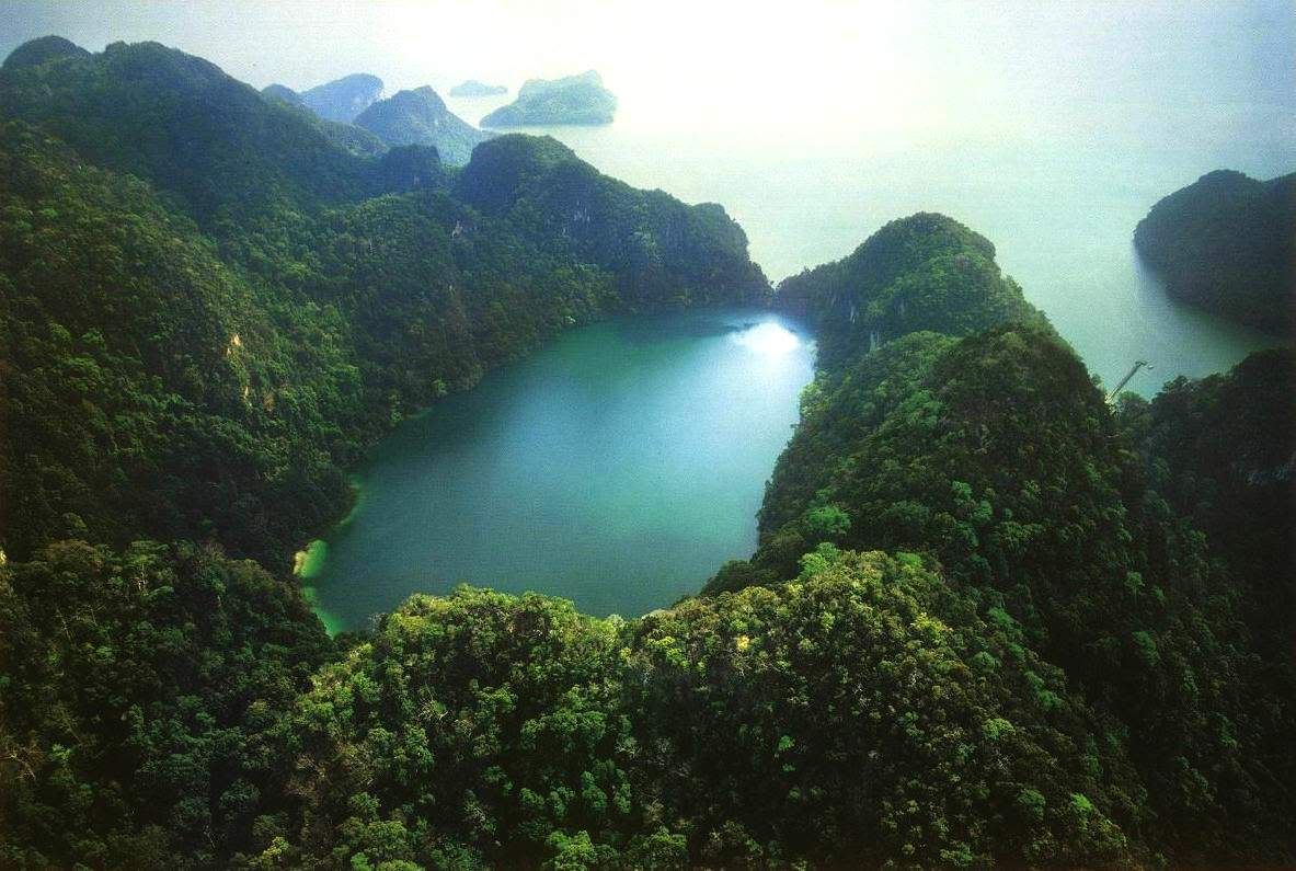
The Beauty of Dayang Bunting Islands
This island gets the name from the story of a giant fairy named Dayang Bunting. This island resembles a giant cursory pregnant complacent. On the way to Lake Dayang Bunting, we'll see a mountain that resembles a woman was lying to the shape of the head, chest and abdomen was pregnant.
Offshore Oil Drilling in Natuna Islands
Rigs drilling for oil and gas can be used not only to identify the geological properties of the reservoir but also to create a hole that allows retrieval of oil or gas content of the reservoir.
Natuna Islands, is one of regencies in Riau Islands Province, Indonesia. Natuna is the northernmost islands in the strait Karimata. In the north, bordering Natuna Vietnam and Cambodia, south of the border with South Sumatra and Jambi, in the western part of Singapore, Malaysia, Riau, and in the east with East Malaysia and West Kalimantan. Natuna is on international cruise lines Hong Kong, Japan, Korea and Taiwan. The county is famous for producing Oil and Gas.

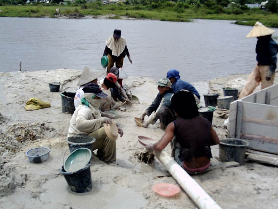
Tin Miners in Bangka
A strength of Ants
Ants are the strongest animals on earth. Although a small body, he is able to sustain the body with a load of 50 times his weight. If the complaint with a very large animals like elephants or gorillas, which can only sustain a maximum of up to three times the object of his weight.

Tomohon Flowers Festival (TFF)

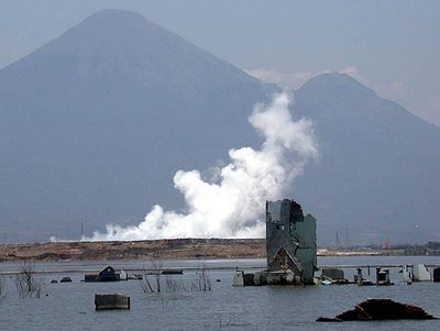
Hot Mud Flood In Sidoarjo, East Java
The Best Wallpapers Collection (Forest Theme)

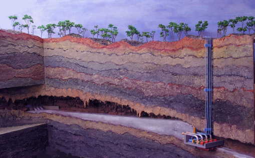
Bribin; Underground Water Dam Project. First in the World
This national-scale cooperation projects involving Batan, IWK Karlsrusche University, Local Government of Yogyakarta, the local government of Gunung Kidul and some universities, such as: ITB, ITS, Pancasila, UGM, UNS and UII.
Infrastructure development projects Bribin II that started in 2005 and was stopped two years since the 2006 earthquake can be enjoyed by residents. Bribin II Water Project water demand is estimated to be sufficient for 80 000 residents of Gunung Kidul.
Sinkhole 60 Meters in Central City of Guatemala
Launched the Daily Mail, Tuesday (1 / 6) mentioned a large hole has a depth of 200 feet (60 meters) where a three-story building also fell into the hole. This large hole appeared in the middle of a huge storm hit the city of Guatemala landslides that followed the current death toll reached 146 people.
Tropical storms that occurred on Sunday and caused massive floods and landslides in Guatemala, Honduras and El Salvador. Guatemala became the country most severely affected.

Big Mushrooms

Langganan:
Postingan (Atom)